|
|
Bulletin of Applied Computing and Information Technology |
|
|
|
|
|
|
|
Flight Simulation Scenery Technologies |
|
02:03 |
|||
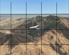
| William Harvey Harvey, W. (2004, November), Flight Simulation Scenery Technologies. Bulletin of Applied Computing and Information Technology Vol. 2, Issue 3. ISSN 1176-4120. Retrieved from ABSTRACTRecent technological advances in the area of personal desktop computer Flight Simulation Software to represent real-world geographical and Topographical terrain, textures and land-objects have led to interesting developments in the field of Aviation and Flight Training. This has resulted in the Aviation Sector looking at this technology as an effective training tool, and perhaps as a new method to log instrument flying hours for student pilots. This paper is looking specifically at some emerging geographical terrain and land-object personal Flight Simulation Software currently being developed by software developers. This will consider the terrain, textures and other land-objects to determine how accurate and useful the sceneries are for real Visual Flight Rules (VFR) flying, whereby pilots fly and navigate mainly by using visual ground reference points instead of relying on instruments. The focus will be on the 3D-Graphical rendering processes and the quality and accuracy of the Simulated Terrain and Geographical Landmarks in the United States, England, New Zealand and South Africa. The methodology will attempt to highlight the technologies as mentioned in the reference material, making a comparison to actual terrain; and in the conclusion to offer some thoughts in summary. KewordsFlight simulation, scenery technologies, replacement scenery technologies, visualisation. 1. INTRODUCTION AND BACKGROUNDMicrosoft Flight Simulator 2004 and some example third party software are used as the flight simulation platform in this study. The scenery within the simulator is built upon a basic mesh grid that represents the height of the ground at any point in the world. This provides the 3-dimensional relief model of hills, mountains, valleys, cliffs, depressions, plateaux and so forth upon which all other scenery objects and ground textures are placed. 2. 1 Microsofts Geographical Terrain And Land-Object SystemMicrosoft has created a layering system to render the default scenery and terrain, and according to PILOT'S GesmbH (2004), to understand Flight Simulator scenery, one can split the scenery in five levels or categories: 2.1.1 "Colour" (landclass scenery)Initially the parameters differentiating the land and ocean areas are identified on a flat surface. This layer includes the data elevation model (DEM) with altitude data (Scenery Design Org., 2004). This scenery layer defines what each cell of the grid looks like (Figure 1). Flight Simulator uses this information to load textures and to generate the generic scenery such as trees and buildings.
2.1.2 "Shape" (elevation mesh)This scenery layer defines the elevation of each point of a grid (or mesh), that is, how the surface and shape of the earth is defined. On top this layer the geographical data gained from satellite imagery is placed that determines the topographical shapes and dimensions of the land areas. The result is a 3-dimensional map created with shaped terrain containing hills, valleys, riverbeds, etc (Figure 2). This grid is then rendered with the image files into a mesh for ground areas. The default terrain uses generic coloured squares that are then tiled to cover the land areas. The smaller the squares within this grid, the more accurate the geographical data will be.
2.1.3 "Objects" (vector scenery)This layer includes all coastlines, water bodies, rivers and roads. The objects are made of lines and polygons that are defined with distinct coordinates and they may modify the shape of the terrain. For example, a lake will flatten all the terrain it covers to one level, which is defined with the object. On a more complex level, this category also includes buildings. Within this layer containing actual objects such as airports, buildings and other landmarks. (Figure 3). Microsoft also includes a feature named Autogen and populates the ground surface with generic objects such as buildings, trees, power lines, etc as illustrated in the background terrain behind the football stadium in Figure 3.
Kane Milne, in his review of the default flight simulator scenery, mentions that these arent just randomly placed. Data is stored in scenery files that tells the Autogen system where towns, forests and farmlands are, and the system places the appropriate objects there to suit. It doesnt recreate cities and towns to their exact layout at all, but it does make areas of terrain recognisable, and makes the entire experience of flight much more involving seeing more than just green tiles passing underneath you... (Gameplanet, 2004). 2.1.4 Aviation objectsTo complete the static scenery, specific objects such as airports, runways, instrument lighting beacons, etc. are placed on top of all the layers (Figure 4).
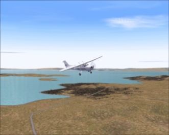
Aeronautical chart information is used for some of the major airports for runway placement, but for the majority of airports longitudinal and latitude points are used and are not always accurate. 2.1.5 Dynamic sceneryTo complete the default scenery, dynamic scenery is added. These include moving objects, such as other airplanes, vehicles or any other type of animated object (Figure 5). Finally, all these components are combined seamlessly into one virtual world.
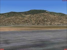
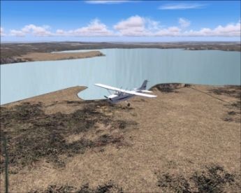
2.2 Default Scenery LimitationsMicrosoft states that the default level of detail within Microsoft Flight Simulator 2004 cannot accurately represent the entire surface of the planet. This is due to the fact that the amount of data required will be too great to fit on most personal computer hard disks. Therefore compromises are made with the mesh grid reference points being 1.22 km or 1,223 meters between each reference point. JustFlight, one of the largest flight simulator developers and publishers of digital aviation products states that this means that there are no relief detail changes under 1.22 kilometres... (JustFlight, 2004). Since the scenery grid between each reference point is so huge, it unfortunately is not detailed enough to render the virtual flight simulator terrain realistic enough compared to the actual scenery for real visual flight rules (VFR) flight. According to Paul Chaney of Horizon Simulations Ltd. the result of this are shortcomings largely in respect of accuracy of the terrain mesh, but with particular attention to the coastlines areas traditionally forgotten about by most other product developers.. (Computer Pilot, p. 24). That means that ground elevation points in-between the grid reference points are missing, resulting in inaccurate scenery as illustrated by these screenshots of the Hauraki Gulf with Rangitoto Island in background in Figure 6. The outline of the land is not accurately rendered and the ground elevation is incorrect as well.
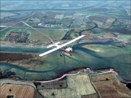
In,Figure 6, the coastlines are not accurately represented either. However, by replacing the landclass and mesh layers with higher resolution terrain data using a smaller grid and combined with satellite images, the quality of the scenery is significantly improved to the level that VFR flying is feasible (Figure 7). Here the coastline has been fixed and the ground elevation corrected.
To address the issues shown in the above example, many software developers are creating add-on software to replace and enhance the default scenery of the visible land. Replacement scenery technologies are being developed to do just this, using various approaches to improve the scenery accuracy within the flight simulator world. Examples of geographical areas which have been re-modelled for VFR flying in the simulator are the United States, England and Wales, and some areas of New Zealand discussed next. 3. REPLACEMENT SCENERY TECHNOLOGIES3.1 FS Global 2005 Replacement SceneryEurope based PILOT'S GesmbH state that their scenery is based on SRTM data (Shuttle Radar Topography Mission.). This data was obtained during February 2000 where a radar interferometry device installed on the Space Shuttle Endeavour gathered elevation data on a near-global scale to generate the most complete high-resolution digital topographic database of Earth. NASA explains that With its radars sweeping most of the Earth's surfaces, SRTM acquired enough data during its ten days of operation to obtain the most complete near-global high-resolution database of the Earth's topography. (Figure 8). To acquire topographic (elevation) data, the SRTM payload was outfitted with two radar antennas.
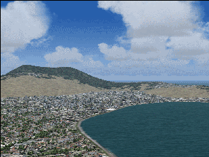
One antenna was located in the shuttle's payload bay, the other on the end of a 60-meter (200-foot) mast that extended from the payload pay once the Shuttle was in space. According to NASA the green colour in Figure 8 indicate one pass and the blue two passes of the shuttle for capturing images (NASA Administration, 2004). They further mention that SRTM data is not directly compatible with any type of Flight Simulator or other widely available software. The data is released as raw data and require some software development for further processing. The Digital Elevation Model (DEM) data is resampled for use with Flight Simulator, compressed and then converted into scenery files, after which the whole process is repeated to compile the scenery at a lower resolution to provide correct views in the distance. To fill these voids a combined approach is used using three methods: Interpolation, resampling of other data sources and manual rework with suitable 3D-software. While the SRTM database is excellent on 99% of the terrain, it has voids (data holes), especially in rough alpine areas, and a correct calculation of the margin of error is required. For small voids they use the interpolation method. This method is quite sophisticated and recognises the shape and character of the surrounding terrain such as ridges and valleys, average and maximum slope and roughness. It would be possible to close all voids absolutely seamlessly by this type of interpolation. However, they mention that for large voids where many square miles of terrain data are missing - the calculated error (or: the possible deviation from real world terrain) would become too large. In such cases they close the gap in the mesh grid using terrain data from other sources. However, most national datasets use different georeference systems and require a coordinate transformation before using them. To minimize the error both methods are combined: with increasing distance from valid SRTM points other datasets are gradually faded in, depending on their own quality or margin of error. For professional applications they are combining SRTM data with expensive proprietary datasets and the SRTM data cover all landmass between 60 degrees north and south latitude. The missing areas are resampled with lower resolution data to offer an improvement over the default scenery. Additionally, a "Double-render" method for flight simulator scenery is used. Flight Simulator loads scenery as needed during the flight, and it happens quite often, that mountains appear suddenly out of nowhere. The "Double-render" scenery eliminates this problem and even at high distance the shape of the scenery is already correct. With "Double-render" scenery there are actually two sceneries running at the same time. However, according to FlightSim Central, the scenery is only a snapshot in time and the scenery for a particular area portrays the scenery only as it was when the picture was taken. This means that to make allowances for the seasons, or time of day, recreating seasonal terrain changes, separate imagery have to be created for each season. The scenery itself carries the marks of the land as well as shadows, which do not move with the sun. They state that photorealistic quality refers to the technique of using samples of photographic textures to represent the landscape over a wide area. For example, a single photograph of a set of fields may be used to display fields in many different locations in a flight simulator... (FlightSim Central, 2004). In order to create a more realistic scenery environment, the simulator uses actual photographs of each location to display the scenery at that location within the flight simulator as seen of the Wellington region in Figure 9. The resulting difference is that all visible features in the real-world landscape are displayed in their true location in the flight simulator.
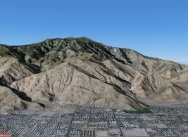
3.2 The United States of America Replacement SceneryAccording to the creators of FS Terrain, a replacement scenery mesh covering the entire continental US has been created using Space Shuttle data ...to dramatically increase the surface detail by up to 16 times with reference points between 76 and 38 metres. Featureless areas are transformed; mountains soar and valleys plunge... (Justflight, 2004). JustFlight claims that the FS Terrain relief model is set at a high resolution of 76.4 metres between each reference point. Aerosoft Australia is creating photorealistic scenery that replaces the default US textures. This is called MegaScenery and is released according to different geographical locations, utilising large-scale satellite photos. Aerosoft state that these satellite images creates a resolution of 5 meters per pixel, which is good enough to accurately reflect real terrain, making it suitable for real VFR flying. (Figure 10) They claim that it creates real rivers, real lakes, real mountains, real farmland, real towns and real cities. Just what youd be seeing if you were really up there.
Aeronautical maps and charts needed to fly in these areas are supplied with the software, for both VFR and IFR Day And Night. They further claim that it is also possible to use real aeronautical charts to fly any VFR route within the scenery areas covered. Aerosoft state that: MegaScenery also uses high resolution Digital Elevation Model data, thats accurate within feet, to provide you with accurate elevation data across the entire area covered. Mountain flying is unlike anything youve ever experienced to the point where you can identify even the slightest ridge or mound and reference it on your aeronautical chart.. . (Aerosoft, 2004). The impact of this technology can clearly be seen in the screenshots of the mountains west of Palm Springs, California. In Figure 12 the replacement scenery detail is significantly more realistic than the default scenery in Figure 11.
Additionally, the scenery defines the areas defined as water as water. This means that water effects are seen with waves and ripples, and only floatplanes are able to land on any body of water within the area covered whereas other planes will sink (Figure 13).
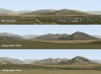
3.3 New Zealand Replacement SceneryVarious flight simulator enthusiasts, most notably Robin Corn from Windowlight, Christian Stock from GeograpX, and Massey Aviation are designing realistic scenery for New Zealand. They are developing the new scenery using satellite imagery of New Zealand, replacing the default scenery. Students from Massey Aviation developed a new landclass system, correcting placement of rivers, roads, lakes for New Zealand. Additionally, the students at Massey Aviation have been developing add-on scenery objects for New Zealand airports and these are then placed on top of the previous layers. Stock has developed high resolution 40m and a lower resolution 150m mesh replacement files for the entire geographical area of New Zealand. This corrects the default mesh scenery (Figure 14).
According to GeoraphX, the New Zealand dataset of digital images consists of more than 300 seamless georeferenced graphic files, with the standard mapsheet covering 40km x 30km (1200 sqkm). Each textured image contains approximately 24.5 megapixels, with a pixel resolution of 7 metres square. Further to this, they state that enhancements include shaded relief, hypsometric colour ramping, and textured forests and water bodies. It is on top of this new layer that the scenery such as those developed by GeographX and Corn is placed, using the satellite imagery with custom New Zealand textures (Figure 15). At present these do not cover all of New Zealand, but some selected areas only.
Reviewing the Godzone scenery created by Corn, one of the major entertainment software suppliers in New Zealand, GamePlanet, states that ...each scenery set covers a limited area. For instance, the Taranaki scenery is 30x40 square kilometres. Beyond that, the default game textures kick in and there is a distinct and sometimes ungainly crossover. This detracts from the natural flow of the landscape unfortunately, and can also have an effect on realism. But within the bounds of the scenery is an environment that is 100% New Zealand as we know it... (GamePlanet, 2003). However, it is clear from the example screenshots of lake Taupo the significant difference the replacement scenery makes. In Figure 16 the default scenery is flat, the waterline not very accurate and the terrain empty using generic textures.
In Figure 17 the waterline is fixed, the terrain elevation is corrected and the terrain covered with accurate textures taken from satellite data with the replacement scenery layers. Even the roads are represented accurately.
3.4 England and Wales Replacement SceneryAccording to Flightsim Central the replacement scenery photographic scenery used for England and Wales uses GetMapping's Millennium Map aerial photography, which is based on photos taken from aircraft flying at around 5,000ft. The result is photographic quality scenery with seamless coverage of entire the United Kingdom (Figure 18). The photographic scenery recreates VFR (Visual Flight Rules) flying in which navigation is by linear features such as motorways and railways, and reporting points are based on prominent visual features in the landscape.
Flightsim Central further state that the photographic scenery is made by draping high quality aerial photography over a 3D model of the terrain so that it can be used by Microsoft Flight Simulator to display it as it might be seen from a plane in real-life (Figure 19).
The photographic scenery recreates VFR flying in which navigation is by linear features such as motorways and railways, and reporting points are based on prominent visual features in the landscape. The resulting photographic quality and seamless coverage "...cannot currently be matched by satellite imagery..." (JustFlight, 2004). They explain the difference between photorealistic and photographic scenery as follows: "Photorealistic" quality refers to the technique of using samples of photographic textures to represent the landscape over a wide area. For example a single photograph of a set of fields may be used to display fields in many different locations in a flight simulator. Photographic scenery uses the actual photograph of each location to display the scenery at that location in the flight simulator. The biggest difference is "...that all visible features in the real-world landscape are displayed in their true location in the flight simulator.. (JustFlight, 2004) In addition they state that This photographic scenery shows not just every major city, but also every town, village, hamlet, wood, field, copse, stream, river, road, railway, canal, shopping centre, factory, in fact every visible feature in between right down to individual streets and houses...(JustFlight,2004). 3.5 Southern AfricaAeroworx Scenery Division, based in South Africa, have developed replacement landclass scenery mesh for the entire southern African continent. They state that the 76m resolution is based on the Space Shuttle Radar Imagery and covers the entire Southern Africa including South Africa, Lesotho, Swaziland, Namibia, Botswana, Zimbabwe, Mozambique, Malawi, Zambia, Angola, Gabon, Congo, DRC, Burundi, Rwanda, Uganda, Tanzania and Kenya. Madagascar, Comoros, Seychelles, Reunion, Mauritius and Sao Tome. Virtual Pilot Magazine mention in their review that the 76m Resolution results in accurate Ground Layer rendering in FS and the splendours of Table Mountain, the Drakensberg and Kilimanjaro are displayed just as if you were looking at the real thing....(SA Virtual Pilot, 2004). An example of this can be seen in Figure 20 and Figure 21 with the shape of Table Mountain in Cape Town more accurately represented in Figure 21.
Using GMax technology, Aeroworx are also creating original 3D models of airport buildings and other unique scenery objects to compliment the landclass scenery mesh. Examples of customized airport sceneries are Johannesburg International, Cape Town International, Bloemfontein., Tempe, Lanseria, etc as seen in Figure 22 of the Johannesburg International (JIA) Terminal.
Virtual Pilot magazine (2004) mentions in their review that One of the things that set Aeroworx airports apart from other sceneries is their extensive use of photorealistic textures. This is especially evident at Wonderboom and JIA, where they have used photographs of the actual buildings to texture their models. Virtual Pilot further mention that they dont just rely on photorealistic textures to make the airport seem real in Flight Simulator the placement of the buildings and the surrounding roads helps to bring them to life. JIA 2004 also includes a lot of custom objects the ubiquitous Nedplan busses, baggage trains, fire trucks, support vehicles and even stacks of pallets transform the apron from the barren expanse of the default scenery into something that actually resembles the real world. 4. RELEVANCE TO REAL AVIATIONFlight Lieutenant Gair Bowbyes, a RAAF flight instructor based at Queensland states: I have been a pilot with the RAAF (though originally from Dunedin) for some 13 years now. I have a background in Tactical transport, Special Forces and Fast Jet ops. I also started Flightsim with the very first version of Flightsim. It's what got me started. My background/interest in Flightsim as a tool has seen my involvement in Flightsim as a simulator for the PC9 in Western Australia (2FTS) and I have initiated flight sim inclusion in powerpoint mass briefs (videos and stills) to the students over the last 5 years that I have instructed as a QFI. Currently I am developing a CT/4 model for the use in FS2004 by students at BFTS Tamworth, and for a new series of Mass Briefs in the lecture package. (Personal Communication, 18 March, 2004) Brian Hesketh, a flying enthusiast based in England, writes: Back in the late 1960s, I learned to fly at Barton airfield in the north of England in a Piper Colt and an Auster. I completed 30 hours, inc. 10 solo and never piloted a plane for decades thereafter. From about Flight Sim 4 onwards I have used a variety of PC-based flight simulators, usually flying single engine general aviation planes. A couple of years ago my wife bought me an hour's flying lesson at Compton Abbas airfield in Dorset. I told the instructor I had flown years ago (I took my log-book) he was quite enthusiastic, and invited me to go through all the pre-flight checks, rather than join him when all was ready. He then took off and handled the radio (Bournemouth) and at 500' or so handed over to me, with a course I had suggested, flying to the coast at Swanage and then back north for about 15 mins or so of practice turns and so on. I was immediately at home in the cockpit and flew with very little direction or intervention from the instructor. (The aircraft was a Cessna 152 by the way). (Personal Communication, 13 March, 2004) 5. CONCLUSIONIf the simulator is to have any actual aviation use, simulator VFR flight would require scenery at a level of realism that is so accurate as to faithfully recreate actual flying environments so that real flight paths can be accurately simulated. Software developers are attempting to create technologies to reach a standard of realism that is as close to the actual real-world environment we live in as is possible. Based on the above discussion, the potential use of the simulation technologies could be as follows: CarpAir suggests that flying schools and clubs or ...initial pilot training and also for qualified pilots to practise and hone their flying skills... (Computer Pilot, Vol 8, p. 22). It has the potential with approval from professionals such as phobia psychologists to introduce nervous passengers to the flying experience. Chaney states that their Getmapping simulator scenery enhancement software is used by professional flight simulation organizations such as Qinetiq and BAE Systems (ibid, p. 24). He further states that the scenery enhancement software are ...designed to give simulation pilots the same views from the virtual cockpit that real pilots enjoy in flight, allowing accurate VFR Navigation over realistic and recognisable terrain..... Although Microsoft Flight Simulator and the plethora of add-on enhancement products have been around for many decades and used by thousands of student pilots and desktop pilots for flight training and familiarisation, many aviation authorities and flight training centres have been slow to formally recognise the value for real flying. However, in the US, Britain and Australia aviation authorities and flying schools are now beginning to recognise the use of these technologies, and in some instances the use of Microsoft Flight Simulator has been incorporated into the flight training syllabuses. In New Zealand the Civil Aviation Authority has not yet recognised the use of these products for private pilot training, nor have most flight training centres included these into training syllabi. It appears from the many flight simulation forums and other resources that many real pilots and student pilots are using for these technologies, and informally many pilots seem to use the flight simulator to practice and familiarise themselves before undertaking actual flights. The issue could therefore be raised as to if formal recognition of these technologies for pilot training in New Zealand by the Civil Aviation Authority and pilot training centres can be considered. 6. ReferencesAeroworx Scenery Design (2004) South African Terrain Mesh Retrieved 26 September from: http://home.telkomsa.net/aeroworx/. Davis. D. (2004) New additions to the flight sim industry, Computer Pilot, Vol 8, Issue 9. Flightsim Central VFR Photographic Scenery: England Vol. 1 Retrieved 22 April 2004 from: http://www.fscentral.com/photscenenwa.html. GameZone (2003) GodZone Scenery Review Retrieved 28 April 2004 from: http://www.gameplanet.co.nz/mag.dyn/Reviews/2708.html . GeographicX (2004) NZ Mesh for Microsoft Flight Simulator 2000/20002/2004 Retrieved 3 May 2004 from: http://www.geographx.co.nz/Products_MSFS.htm. JustFlight (2004) FS Terrain Retrieved 3May 2004 from: http://www.justflight.com/en/(i140debena0ynw45fkb3hnya)/index.aspx. Massey Aviation (2004) Special Topic Retrieved 2 May 2004 from: http://www.massey.ac.nz/%7Eavweb/papers/fltsimdesign/scenery1.html. PILOT'S GesmbH Microsoft Flight Simulator 2002 and 2004 (76m resolution WORLDWIDE) Retrieved 2 Sep 2004 from: http://fsglobal2005.com/. SceneryDesign Org. (2004) Tutorial: Scenery Design the FS 2004 Way Retrieved 29 April from: http://www.scenerydesign.org/modules.php?name=News&file=article&sid=86. NASA Administration (2004) Shuttle Radar Topography Mission Retrieved 25 May 2004 from: http://www2.jpl.nasa.gov/srtm/mission.htm. Virtual Pilot Magazine (2004) Aeroworx Scenery, Retreived 29 September from: http://www.virtualpilot.co.za/aeroworx.html. Copyright © 2004 William Harvey |
|||||
|
|
|
|
|
|
|
|
Copyright © 2004 NACCQ. All rights reserved. |
|||||